Burgundy By Bike
Burgundy has almost 1000km of signposted and safe cycling trails, the majority form "Le Tour de Bourgogne a velo". Follow the link to the Burgundy Tourism site where stages of the route are listed. They are made up of Greenway routes and cycling routes, usually running alongside canals along the towpaths, but also traveling down former railway lines or across small roads and pathways through vineyards.
From the beautiful riverside city of Auxerre to Dijon, Burgundy’s splendid capital, this area has cultural and gastronomic stops aplenty. Remarkable sights include Alésia, where Caesar defeated the Gauls, the Voûte de Pouilly, an impressive canal tunnel, and hilltop Châteauneuf-en-Auxois. This area is one of the most important French wine appellations and you will see plenty of wine tourists visiting the origin of their favorite wine.
This is a route that is relatively flat since it follows canal paths and old rail lines. The route travels through some of the oldest and most valuable vineyards in the world. So if you like wine this is the ride for you.
Guides, Maps and Other Information

Office of Tourism for riding in Burgundy. Check out the Itineraries tab for maps and route descriptions. Be sure to order the available maps and brochures, look for the link at the bottom of the page.

Burgundy Office of Tourism A more generalized Burgundy site for bicyclist. Has some links to the EuroVelo routes.

France Velo Tourisme use the dropdown list under "Find My Cycle Route" to get a list of all the potential stages. Has a helpful rating system.

Experience France A site similar to this but dedicated to cycling in France. Try the page "Cycling Across France: 10 Favorite Places".
See the Maps and Guides page for more mapping information.
Map information
There are many cycling apps with maps available for iphone and android. A couple of the better offline apps are listed here.
 Can be used to follow this and other routes. Click here for a KML file that can be loaded into the app. Burgundy Cycleways. Place the file in the maps.me bookmarks folder (MapsWithMe/bookmarks or alternately, email/text it to your device and open the file with maps.me. Total Commander works great for managing and opening files.
 Guru Maps has the ability to show map types other than OpenStreetMap, in particular it will display OpenCycleMap.
What it is Like
The Burgundy area can be accessed by train from Paris which is probably the easiest method for getting to one of the stages. Trains from Paris will stop in Tonnerre or Auxerre and do take bikes. Cities in Burgundy are excellent for touring and site seeing. Dijon and Beaune are import wine cities, you won't run out of things to do here. This area is never boring, there are local markets, ancient cities, and endless scenery.
This ride connects to the Loire Valley and EuroVelo 6 allowing the traveler to extend their trip across Europe.
- Ride Quality
Almost all of the route is paved. The few sections that are on packed gravel are easily done on a hybrid bike. Use the detailed maps and descriptions found on the France Velo Tourisme site to know which sections are path, road, or some combination. The Google map provided here in the upper right shows the entire route. Click on the stage of interest to see the name of the stage and find it on the France Velo Tourisme site.
 Freewheeling France has much information about bicycles and french trains.

A few sections of the route are on packed gravel but are easily rideable. This is the some of the best European canal and riverside travel. Routes are easy to follow
- Elevation Change
The route is mostly level as it follows canal tow paths. There are a few ups and downs as you cross river valleys. Parc Naturel Regional du Morvan is definitely hilly but low traffic and beautiful countryside.

Take a look at the ancient lavoires along the canal
- Best Season
Spring and Fall. Winters are cold and summers are too hot.
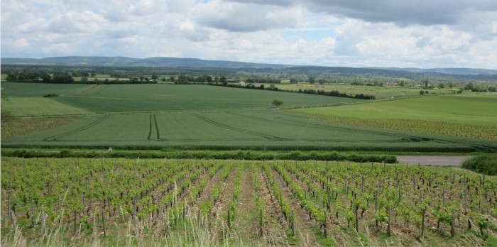
The highlight of this area is route between Dijon and Beaune which travels through some of the most famous and expensive vineyards in Europe. Stop for wine tasting along the way or pick up a bottle in the local shops.

Vineyards and farmlands outside of Beaune
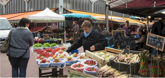
There are many historical villages and sites in the burgundy area. The markets are great and have wide selection of local foods

Market in Dijon in the spring. Strawberries, spargle, apples and other local produce are available.

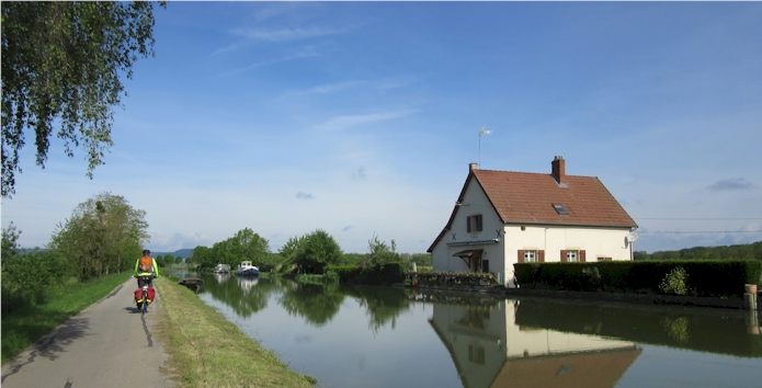
Along the Nivernais canal linking the Yonne and the Loire Rivers.

We always seem have an audience when riding in Europe. Burgundy is a rural, agricultural area that is great for bicycle rides.