Belgium: The Meuse
Following one of the most important rivers in Europe, The Meuse travels through three countries, Netherlands, Belgium, and France. From the plateau of Langres in France to the town of Hoek van Holland the cycleway covers over 1100 kilometers of cycle path and marked roads through the many historic towns and villages spread out along the cycleway.
The Meuse/Mass is one of the most historically important transportation corridors in Europe. Students of World War II history will find many monuments and historical markers along this route. The location where the Meuse crosses the French border and Ardennes Forest marks one of the key final battles of WWII.

City of Huy, Wallonia. In Belgium the old and the new can be found side by side. Belgium is more industrialized than some of its neighbors but there are still many things to do and see along the many bike routes.
Guides, Maps and Other Information
Maas Cycleway. Official site for the Meuse/Maas cycleway. Includes GPX tracks, map information and route descriptions.
Ravel et Veloroutes. Official site for bicycle routes in Wallonia. The routes seem to be as advertised and are signed in most areas. From the U.K Belgium site: "The RAVeL cycling network comprises more than 1,350km of disused rail track, byway and canal towpath made up of 45 amazing cycling routes. The routes are the equivalent in distance between London and Inverness with easy to manage gradients. A RAVeL adventure is a relaxing way to enjoy unspoilt villages, historic towns, flowing rivers and serene lakes."
![]() EuroVelo 19: The Meuse. Lots of information on this official site for the Meuse. Guides and maps are available. Launched in March of 2019, this is a new addition to the EuroVelo system.
EuroVelo 19: The Meuse. Lots of information on this official site for the Meuse. Guides and maps are available. Launched in March of 2019, this is a new addition to the EuroVelo system.
![]() EuroVelo 3: The Pilgrims Route. A 5,100 km route part of which travels through Wallonia.
EuroVelo 3: The Pilgrims Route. A 5,100 km route part of which travels through Wallonia.
Cycletourer: Cycling in Belgium. A good summary of cycling in Belgium with map references and links to useful information.
See the Maps and Guides page for more mapping information.
Map information
There are many cycling apps with maps available for iphone and android. A couple of the better offline apps are listed here.
![]() Can be used to follow this route (and other routes). Place a KML file in the maps.me bookmarks folder (MapsWithMe/bookmarks on your phone or tablet) or alternately, email/text it to your device and open the file with maps.me. Total Commander works great for managing and opening files.
Can be used to follow this route (and other routes). Place a KML file in the maps.me bookmarks folder (MapsWithMe/bookmarks on your phone or tablet) or alternately, email/text it to your device and open the file with maps.me. Total Commander works great for managing and opening files.
![]() Guru Maps has the ability to show map types other than OpenStreetMap, in particular it will display OpenCycleMap. KML files can be imported by "opening" the file with Guru. To import the KML file place the file in a folder or email/text it to your device, press and hold and open with the app. The route will appear in "collections." A user manual is available.
Guru Maps has the ability to show map types other than OpenStreetMap, in particular it will display OpenCycleMap. KML files can be imported by "opening" the file with Guru. To import the KML file place the file in a folder or email/text it to your device, press and hold and open with the app. The route will appear in "collections." A user manual is available.
What it is Like
We have only ridden the lesser traveled southern half of Belgium (Wallonia) One of the most highly industrialized areas of Europe during the industrial revolution, you can see many remnants of steel and coal production is this area. The bicycle paths can be a little rougher here and slower going but its still well worth the trip. The area is rich in history and home to some famous battle grounds. The area is crossed by many bike paths and routes that will take you to the far corners of Wallonia. Paths are well marked and easily navigated.
Most of this ride along the Meuse is on dedicated bicycle paths with only a few detours on small roads. Many interesting aspects of commerce on a major European water can be seen such as barges, tour ships, and fishing vessels. Watching a large freighter travese the locks is something to look out for.
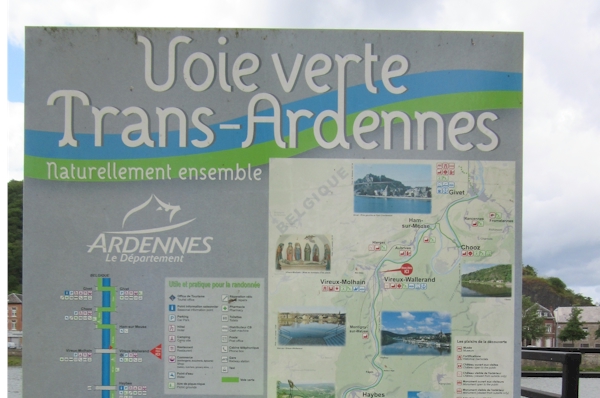
Signs for the Voie verte Trans-Ardennes in France
The Meuse (Maas) cycleway comprises the Trans-Ardennes route in France which is a wonderful ride and well worth the time it takes to get there. This ride follows the Meuse between Charleville-Mézières and Givet. Take note, there is no direct train connection between Givet and Dinant but the route is easily rideable, just allow extra time to make your connections.
- Ride Quality
The cycleways in Belgium are overall pretty good but can be rough in places. Some areas are very scenic and forested or agricultural such as Dinant. Other areas are industrial or have the remnants of industrial development. The cycleways are well designed are have little to no vehicle traffic. Signs are posted with maps along the way.

Dinant Belgium. The cycle route in this area follows the Meuse river.
- Elevation Change
The routes are mostly level but in some areas the routes travel through hilly terrain. Although the steeper sections are on roads, traffic is very light. Strong winds can be present in the river valleys. Winds are generally from the south in the summer months. The easiest way to ride this area is to go with the flow, follow the river down stream.
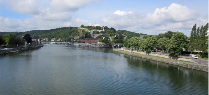
The Meuse cycle path can be seen on the right side of the photo. The path stays close to the river for most of the distance.
- Best Season
Spring and Fall. Summers can be hot and wet and winters are cold. Most accommodations do not have air conditioning.
- Options
If flying into one of Europe's major airport, you can take a train to the upper Meuse in France and ride downriver and with the wind. Winds are generally downriver and can be very strong. If your traveling by train, keep in mind that there is no train connection between Givet in France and Dinant in Belgium. It is an easy an pleasant ride between the towns.
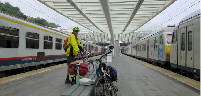
Regional and intercity trains have space for bicycles, usually at the end or beginning of the train.